
1 November 1755 · a city changed
The 1755 Lisbon earthquake, and what came next
On 1 November 1755, an earthquake, tsunami and fires devastated Lisbon. At Carmo, the roofless church makes the story visible, but it is not simply a building untouched since that morning. Reconstruction began afterwards and was later abandoned; the open nave became a memorial. That is the detail we would carry into a visit: even a ruin has a history after the disaster.
In short
The Lisbon earthquake struck on 1 November 1755, followed by a tsunami and fires. Carmo’s roofless nave is a visible memorial, but also contains later reconstruction. Pair it with rebuilt Baixa and Praça do Comércio to understand both the disaster and the decisions afterwards. Use the museum account rather than treating every arch as untouched rubble.
1755 · 1755, the day the city changed
Roman era
Roman Olisipo, Lisbon under your feet
Roman Lisbon was Felicitas Iulia Olisipo. Its first-century theatre is still here, on the hillside at Rua de São Mamede. That changes the way we look at a walk around the cathedral: the city is not just old façades, but buildings and streets laid over earlier lives. Start with the theatre rather than trying to turn every loose stone into a Roman relic.
Still here today
The archaeological remains of a first-century theatre, interpreted by Museu de Lisboa.
Where to stand
Museu de Lisboa – Teatro Romano, Rua de São Mamede 3A. The pin is a building reference, not a verified step-free entrance.
Try three quick questions
No score to share. Just something to take on your walk.

8th century–1147
Islamic Lisbon, beyond a skyline
Islamic Lisbon is easier to understand through a house than a postcard. The castle's archaeological area preserves an eleventh- and twelfth-century residential quarter: rooms around courtyards, storage spaces and drainage. These were places to live, not just walls to defend. We would start with that domestic scale, then look across the present city. The castle silhouette alone cannot tell you which century you are seeing.
Still here today
Remains of houses, courtyards and streets in the castle's archaeological area.
Where to stand
Castelo de São Jorge. This is the public castle reference; follow the operator's arrangements for the archaeological area.
Try three quick questions
No score to share. Just something to take on your walk.

1147
1147, a conquest and its layers
Afonso Henriques took Lisbon on 25 October 1147 with the help of crusaders. The date marks a change of rule, not the instant creation of the city visible today. The castle hill had earlier inhabitants, and its buildings were altered again afterwards. Give the date its place, then keep looking for the layers on either side of it. A single skyline is a poor substitute for several centuries.
Still here today
The castle hill remains a place to read successive occupations, rather than a frozen scene from the siege.
Where to stand
Castelo de São Jorge. The map locates the modern monument, not troop positions or a reconstructed siege boundary.
Try three quick questions
No score to share. Just something to take on your walk.
1498
Belém, voyages and the city they changed
Vasco da Gama reached Calicut in India on 20 May 1498. Belém is a useful place to follow the Lisbon end of that story, but keep the dates straight: work on Jerónimos Monastery began in 1501. The monument is part of what followed the voyages, not a building the departing fleet sailed past. Look at the stonework, then consider how trade and royal ambition could become architecture on this scale.
Still here today
Jerónimos Monastery, whose building campaign began in 1501 and was funded in part from trade revenues.
Where to stand
Jerónimos Monastery in Belém. Use the pin to find the monument; the voyage’s departure point is not plotted on this map.
Try three quick questions
No score to share. Just something to take on your walk.

1755
1755, the day the city changed
On 1 November 1755, an earthquake, tsunami and fires devastated Lisbon. At Carmo, the roofless church makes the story visible, but it is not simply a building untouched since that morning. Reconstruction began afterwards and was later abandoned; the open nave became a memorial. That is the detail we would carry into a visit: even a ruin has a history after the disaster.
Still here today
Carmo's open nave, preserved as a memorial; the museum explains its later rebuilding and the decision to leave it roofless.
Where to stand
Largo do Carmo, the public square beside the museum. Go inside the museum to see the nave; the square pin is not an admission or entrance claim.
Try three quick questions
No score to share. Just something to take on your walk.

1758
The Pombaline rebuild, street by street
The reconstruction plan approved in 1758 helped give Baixa a new order after the disaster. Manuel da Maia, Eugénio dos Santos, Carlos Mardel and the future Marquis of Pombal belong in the story, rather than one heroic name doing everything. From Praça do Comércio, look back towards the streets. Planning was about the city working again as well as how it looked, including a new drainage network below the pavement.
Still here today
Baixa's rebuilt street pattern and Praça do Comércio; the municipal history of Rua da Prata also documents the drainage system.
Where to stand
Praça do Comércio, then look north into Baixa. This is a modern square reference, not the outline of the pre-earthquake palace.
Try three quick questions
No score to share. Just something to take on your walk.

1908 / 1910
Two squares, the end of a monarchy
Two squares keep this chapter in focus. King Carlos and his heir Luís Filipe were killed at Terreiro do Paço on 1 February 1908. On 5 October 1910, José Relvas proclaimed the Republic from the City Hall balcony at Praça do Município. The places are close in the city, but the events are not the same day or the same square. Stand still for a moment and let that distinction do the work.
Still here today
The two public settings: Praça do Comércio / Terreiro do Paço and the City Hall frontage on Praça do Município.
Where to stand
Praça do Município, facing City Hall. The public square pin is for the proclamation setting, not the 1908 shooting site.
Try three quick questions
No score to share. Just something to take on your walk.
1974
25 April, freedom in the streets
On 25 April 1974, the military movement and people in the streets brought down the dictatorship. Largo do Carmo was a decisive setting: Marcelo Caetano took refuge in the barracks, surrounded by Salgueiro Maia's forces. The cheerful symbol of carnations should not flatten the day into a harmless postcard. The Aljube chronology records deaths outside the political police headquarters as well as the celebration of freedom.
Still here today
Largo do Carmo as a public setting of the revolution. The nearby church and the barracks are different buildings.
Where to stand
Largo do Carmo. Read the Aljube chronology to place the barracks and other events; the marker represents the square, not an interior visit.
Try three quick questions
No score to share. Just something to take on your walk.
1988
Chiado, rebuilt rather than replaced
A major fire struck Chiado on 25 August 1988. Álvaro Siza's reconstruction belongs to the history of the district you walk through now, not just to an architecture textbook. The lesson is different from 1755: two disasters, in different centuries, followed by different rebuilding decisions. Keep both in mind without merging them into a single story of old Lisbon burning and returning unchanged.
Still here today
Rebuilt Chiado and the Terraços do Carmo, part of the long recovery described by the municipality.
Where to stand
Chiado. The map is a neighbourhood reference, not the ignition point or a diagram of the burned area.
Try three quick questions
No score to share. Just something to take on your walk.

1998
Expo 98, a different Lisbon waterfront
Expo 98 opened on 22 May 1998 with the oceans as its theme. The fair ended, but the waterfront did not disappear with it. The Oceanário, pavilions, gardens and public spaces remain part of Parque das Nações. Come here after the older centre and the contrast is useful: Lisbon's history is not finished at the last tiled façade. The modern city deserves a chapter of its own.
Still here today
The Oceanário, former exhibition pavilions, gardens and public spaces that the parish council identifies with the Expo legacy.
Where to stand
Parque das Nações. The pin locates the present district, not the vanished exhibition ticket gates.
Try three quick questions
No score to share. Just something to take on your walk.

Same river. A different city.
A window between two Lisbons.
Look through the circle: an eighteenth-century painting gives way to a photograph from 2018.
The same riverfront, from different viewpoints—not an exact alignment.
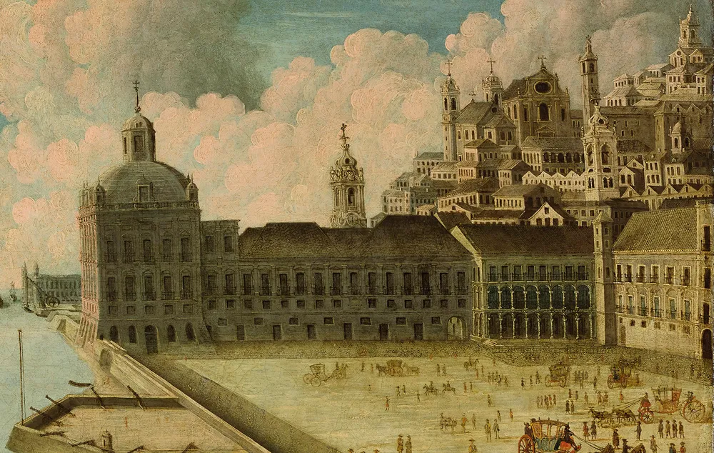
Tap or drag the circle. Keyboard: use the arrow keys, or the sliders below.
Adjust the lens with sliders
Earthquake, tsunami and fire
The earthquake of 1 November 1755 was followed by a tsunami and fires. Those are related hazards, not interchangeable words for one event. IPMA’s historical account documents the tsunami; the city’s rebuilding history explains the destruction and the response.
We do not publish a precise death toll, wave height or magnitude here as though every account agrees. To understand the place today, start with the memorial at Carmo and then look at the streets and riverfront that were redesigned.
Carmo is a memorial with its own later history
Carmo's open nave, preserved as a memorial; the museum explains its later rebuilding and the decision to leave it roofless.
The museum explains that reconstruction began in 1756, stopped in 1834 and was later left unfinished. Its nave is open to the sky by later decisions as well as by the damage of 1755. The surviving arches should not all be described as untouched medieval remains.
1758: a plan, not a city finished overnight
The reconstruction plan approved in 1758 helped give Baixa a new order after the disaster. Manuel da Maia, Eugénio dos Santos, Carlos Mardel and the future Marquis of Pombal belong in the story, rather than one heroic name doing everything. From Praça do Comércio, look back towards the streets. Planning was about the city working again as well as how it looked, including a new drainage network below the pavement.
Follow the street alignments with your eyes before walking into the grid. The old painting and modern photograph show the same riverfront setting from different viewpoints, not a survey overlay.
Two places to see, one unhurried outing
Largo do Carmo, the public square beside the museum. Go inside the museum to see the nave; the square pin is not an admission or entrance claim.
Praça do Comércio, then look north into Baixa. This is a modern square reference, not the outline of the pre-earthquake palace.
Decide whether you want to enter the Carmo museum or start with the public spaces. The square outside and the nave inside are different stops; admission and visiting arrangements belong to the museum. Use the destination links without sending your location to Lisbonline.
The map and photographs are historical orientation, not an emergency route. For present-day warnings, follow the responsible authorities. This guide does not predict an earthquake or turn the waterfront into an evacuation recommendation.
Three details to keep separate
The earthquake, tsunami and fires were distinct parts of the disaster. The rebuilding plan was approved later, in 1758. Carmo’s present nave also reflects reconstruction and later preservation, rather than only the first day’s destruction.
Quick answers
When was the Lisbon earthquake?
The earthquake struck on 1 November 1755 and was followed by a tsunami and fires. Carmo and rebuilt Baixa give different ways to understand what happened and what came afterwards.
Does the map reconstruct Lisbon in each era?
No. It highlights present-day places linked to the selected era. Historical walls, shorelines and siege lines are not drawn without a verified, licensed source.
Was Carmo left exactly as it fell in 1755?
No. Reconstruction began after the earthquake and was later abandoned. The museum describes later arches and the decision to leave the nave open as a memorial.
Keep planning
Historical sources
The historical accounts below come from museums, the municipality and public institutions. They do not verify today’s opening hours or tickets. Map locations and photograph dates have their own scope.